Sidewalk Labs' proposals for the Toronto neighborhood of Quayside reveals a preference for ride hailing over public transit.
Paris Marx has read the response to the Request for Proposals for a high-profile "smart city" project in the Toronto neighborhood of Quayside, and what he found will not be welcome among transit advocates.
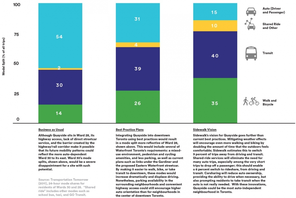
Marx points to page 133 of the proposal, finding a graph that reveals the transportation priorities of Sidewalk Labs. According to Mark, if Sidewalk Labs pursues its vision, "[t]ransit use would only increase by a single percentage point, while automobile use would be reduced to 15 percent by a larger uptake of walking and cycling (35 percent) and the use of driverless vehicles, ride hailing, and car share services (10 percent)."
There are several specific sections of the proposal that Marx reads as giving priority to ride hailing and driverless vehicles—even potentially over pedestrians and cyclists. The proposals calls for "non-hierarchical streets," for instance, would abandon the complete streets layout that most benefits alternative transportation, according to Marx. The most troubling section of the report, to Marx, is the call for shared ride zones, "where Quayside residents would get subsidized shared-ride trips instead of taking transit."1
- 1. Source: Planetizen
In its partnership with Waterfront Toronto to build a city “from the internet up” near downtown Toronto, Alphabet subsidiary Sidewalk Labs has a lot of great ideas, but how they will look in a working city is still a major question. Transportation is among the urban systems that Sidewalk promises to remake in Quayside — the 12-acre (4.9-hectare) site on Toronto’s waterfront that the company has a role in co-planning — but instead of promoting efficient transit, priority is given to ride hailing and driverless cars.
On page 133 of its Request for Proposal (RFP), Sidewalk lays out three scenarios for transportation mode share. One would be forgiven for thinking that the bar on the left represents Toronto’s current mode share, but that’s not the case. That’s the 2011 mode share of auto-dependent Ward 30, which contains much of the Eastern Waterfront where Sidewalk hopes to expand once it has proven itself in Quayside, and with 54 percent of all trips made by automobile and only 30 percent by transit, it does present a negative picture. But it would be misleading to think that represents the whole of Toronto.
....
Without a deeper read, this chart [below] makes it look like Sidewalk’s plan would be a major improvement on the current mobility patterns in the city, but the picture is more mixed. The numbers show that transit use has increased over the past decade, along with walking and cycling, and it would be reasonable to believe that the same applies to Ward 28, meaning the small transit increase predicted by Sidewalk may already be the area’s reality.
....
Sidewalk claims to be designing a city that would work better for people, but its street layout would not deliver. Oddly, the illustrations included in Sidewalk’s RFP refute the whole section about its “hierarchical” street pattern. It show a long, straight street lined with trees to make it more pleasant and with plenty of space for pedestrians and cyclists that is shared with transit and driverless vehicles. Sidewalk needs to make up its mind about what kind of streets it really wants.
....

